|
|
|||||||||||||||||
| Point ID: 5 | Downloads | Plots | Site Data | Code: 05AA005 |
|
|
|||||||||||||||||
| Download | |
|---|---|
| Site Descriptor Information | Site Time Series Data |
| Link to all available data | |
| View: | Time Series | All |
| Units: | mm |
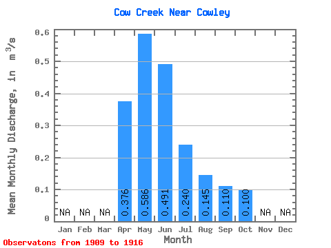
| Statistic | Jan | Feb | Mar | Apr | May | Jun | Jul | Aug | Sep | Oct | Nov | Dec | Annual |
|---|---|---|---|---|---|---|---|---|---|---|---|---|---|
| Mean | 0.38 | 0.59 | 0.49 | 0.24 | 0.14 | 0.11 | 0.10 | ||||||
| Standard Deviation | 0.12 | 0.22 | 0.34 | 0.22 | 0.11 | 0.09 | 0.05 | ||||||
| Min | 0.26 | 0.34 | 0.11 | 0.03 | 0.01 | 0.02 | 0.03 | ||||||
| Max | 0.48 | 0.89 | 1.05 | 0.59 | 0.35 | 0.30 | 0.18 | ||||||
| Coefficient of Variation | 0.31 | 0.38 | 0.69 | 0.90 | 0.75 | 0.81 | 0.46 |
 Return to R-Arctic Net Home Page