|
|
|||||||||||||||||
| Point ID: 492 | Downloads | Plots | Site Data | Code: 05EA004 |
|
|
|||||||||||||||||
| Download | |
|---|---|
| Site Descriptor Information | Site Time Series Data |
| Link to all available data | |
| View: | Time Series | All |
| Units: | mm |
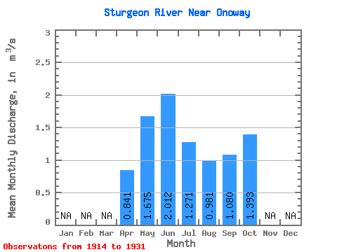
| Statistic | Jan | Feb | Mar | Apr | May | Jun | Jul | Aug | Sep | Oct | Nov | Dec | Annual |
|---|---|---|---|---|---|---|---|---|---|---|---|---|---|
| Mean | 0.84 | 1.68 | 2.01 | 1.27 | 0.98 | 1.08 | 1.39 | ||||||
| Standard Deviation | 1.23 | 1.52 | 1.65 | 1.08 | 0.68 | 0.96 | 1.39 | ||||||
| Min | 0.01 | 0.01 | 0.02 | 0.01 | 0.00 | 0.00 | 0.00 | ||||||
| Max | 2.63 | 4.06 | 3.81 | 2.18 | 1.57 | 2.14 | 2.92 | ||||||
| Coefficient of Variation | 1.46 | 0.91 | 0.82 | 0.85 | 0.70 | 0.89 | 1.00 |
 Return to R-Arctic Net Home Page