|
|
|||||||||||||||||
| Point ID: 490 | Downloads | Plots | Site Data | Code: 05EA002 |
|
|
|||||||||||||||||
| Download | |
|---|---|
| Site Descriptor Information | Site Time Series Data |
| Link to all available data | |
| View: | Time Series | All |
| Units: | mm |
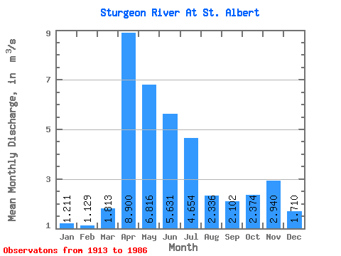
| Statistic | Jan | Feb | Mar | Apr | May | Jun | Jul | Aug | Sep | Oct | Nov | Dec | Annual |
|---|---|---|---|---|---|---|---|---|---|---|---|---|---|
| Mean | 1.21 | 1.13 | 1.81 | 8.90 | 6.82 | 5.63 | 4.65 | 2.34 | 2.10 | 2.37 | 2.94 | 1.71 | 6.33 |
| Standard Deviation | 0.76 | 0.72 | 1.81 | 6.08 | 6.21 | 6.91 | 5.79 | 2.26 | 2.03 | 1.98 | 0.06 | 0.28 | |
| Min | 0.67 | 0.62 | 0.00 | 0.67 | 1.08 | 0.72 | 0.08 | 0.00 | 0.00 | 0.00 | 2.90 | 1.51 | 6.33 |
| Max | 1.75 | 1.64 | 5.71 | 20.10 | 25.50 | 27.10 | 21.70 | 9.11 | 8.20 | 6.79 | 2.98 | 1.91 | 6.33 |
| Coefficient of Variation | 0.63 | 0.64 | 1.00 | 0.68 | 0.91 | 1.23 | 1.24 | 0.97 | 0.96 | 0.83 | 0.02 | 0.17 |
 Return to R-Arctic Net Home Page