|
|
|||||||||||||||||
| Point ID: 486 | Downloads | Plots | Site Data | Code: 05DF004 |
|
|
|||||||||||||||||
| Download | |
|---|---|
| Site Descriptor Information | Site Time Series Data |
| Link to all available data | |
| View: | Time Series | All |
| Units: | mm |
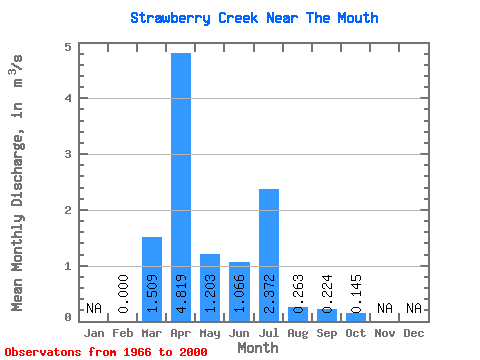
| Statistic | Jan | Feb | Mar | Apr | May | Jun | Jul | Aug | Sep | Oct | Nov | Dec | Annual |
|---|---|---|---|---|---|---|---|---|---|---|---|---|---|
| Mean | 0.00 | 1.51 | 4.82 | 1.20 | 1.07 | 2.37 | 0.26 | 0.22 | 0.14 | ||||
| Standard Deviation | 1.79 | 5.12 | 1.37 | 1.66 | 3.94 | 0.34 | 0.49 | 0.16 | |||||
| Min | 0.00 | 0.00 | 0.14 | 0.05 | 0.01 | 0.01 | 0.00 | 0.00 | 0.00 | ||||
| Max | 0.00 | 7.49 | 24.50 | 6.21 | 8.57 | 14.90 | 1.61 | 2.65 | 0.73 | ||||
| Coefficient of Variation | 1.18 | 1.06 | 1.14 | 1.56 | 1.66 | 1.31 | 2.19 | 1.11 |
 Return to R-Arctic Net Home Page