|
|
|||||||||||||||||
| Point ID: 485 | Downloads | Plots | Site Data | Code: 05DF003 |
|
|
|||||||||||||||||
| Download | |
|---|---|
| Site Descriptor Information | Site Time Series Data |
| Link to all available data | |
| View: | Time Series | All |
| Units: | mm |
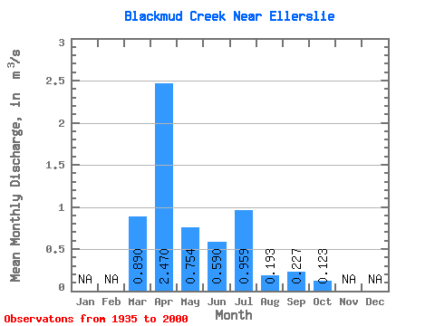
| Statistic | Jan | Feb | Mar | Apr | May | Jun | Jul | Aug | Sep | Oct | Nov | Dec | Annual |
|---|---|---|---|---|---|---|---|---|---|---|---|---|---|
| Mean | 0.89 | 2.47 | 0.75 | 0.59 | 0.96 | 0.19 | 0.23 | 0.12 | |||||
| Standard Deviation | 0.96 | 2.36 | 1.15 | 1.09 | 1.72 | 0.27 | 0.62 | 0.28 | |||||
| Min | 0.00 | 0.03 | 0.01 | 0.01 | 0.01 | 0.00 | 0.00 | 0.00 | |||||
| Max | 3.25 | 9.32 | 5.03 | 4.68 | 8.27 | 1.06 | 3.15 | 1.22 | |||||
| Coefficient of Variation | 1.07 | 0.95 | 1.52 | 1.84 | 1.80 | 1.41 | 2.75 | 2.27 |
 Return to R-Arctic Net Home Page