|
|
|||||||||||||||||
| Point ID: 484 | Downloads | Plots | Site Data | Code: 05DF002 |
|
|
|||||||||||||||||
| Download | |
|---|---|
| Site Descriptor Information | Site Time Series Data |
| Link to all available data | |
| View: | Time Series | All |
| Units: | mm |
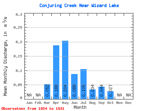
| Statistic | Jan | Feb | Mar | Apr | May | Jun | Jul | Aug | Sep | Oct | Nov | Dec | Annual |
|---|---|---|---|---|---|---|---|---|---|---|---|---|---|
| Mean | 0.05 | 0.19 | 0.20 | 0.09 | 0.10 | 0.03 | 0.04 | 0.03 | |||||
| Standard Deviation | 0.07 | 0.21 | 0.37 | 0.06 | 0.18 | 0.04 | 0.07 | 0.03 | |||||
| Min | 0.00 | 0.00 | 0.00 | 0.02 | 0.00 | 0.00 | 0.00 | 0.01 | |||||
| Max | 0.10 | 0.47 | 0.95 | 0.18 | 0.42 | 0.11 | 0.15 | 0.08 | |||||
| Coefficient of Variation | 1.41 | 1.12 | 1.81 | 0.70 | 1.70 | 1.27 | 1.61 | 1.22 |
 Return to R-Arctic Net Home Page