|
|
|||||||||||||||||
| Point ID: 453 | Downloads | Plots | Site Data | Code: 05DB003 |
|
|
|||||||||||||||||
| Download | |
|---|---|
| Site Descriptor Information | Site Time Series Data |
| Link to all available data | |
| View: | Time Series | All |
| Units: | mm |
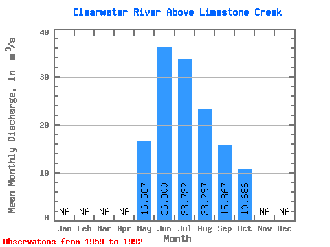
| Statistic | Jan | Feb | Mar | Apr | May | Jun | Jul | Aug | Sep | Oct | Nov | Dec | Annual |
|---|---|---|---|---|---|---|---|---|---|---|---|---|---|
| Mean | 16.59 | 36.30 | 33.73 | 23.30 | 15.87 | 10.69 | |||||||
| Standard Deviation | 6.46 | 14.80 | 12.57 | 6.05 | 4.21 | 2.91 | |||||||
| Min | 6.48 | 15.30 | 17.20 | 15.80 | 9.49 | 5.42 | |||||||
| Max | 32.30 | 78.20 | 69.20 | 45.60 | 27.50 | 20.30 | |||||||
| Coefficient of Variation | 0.39 | 0.41 | 0.37 | 0.26 | 0.27 | 0.27 |
 Return to R-Arctic Net Home Page