|
|
|||||||||||||||||
| Point ID: 4459 | Downloads | Plots | Site Data | Code: 05QE012 |
|
|
|||||||||||||||||
| Download | |
|---|---|
| Site Descriptor Information | Site Time Series Data |
| Link to all available data | |
| View: | Time Series | All |
| Units: | mm |
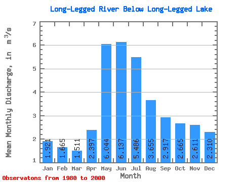
| Statistic | Jan | Feb | Mar | Apr | May | Jun | Jul | Aug | Sep | Oct | Nov | Dec | Annual |
|---|---|---|---|---|---|---|---|---|---|---|---|---|---|
| Mean | 1.92 | 1.67 | 1.51 | 2.40 | 6.04 | 6.14 | 5.49 | 3.66 | 2.92 | 2.67 | 2.61 | 2.31 | 3.28 |
| Standard Deviation | 0.90 | 0.64 | 0.50 | 1.21 | 3.97 | 3.40 | 3.05 | 2.05 | 2.43 | 2.11 | 1.90 | 1.39 | 1.30 |
| Min | 0.46 | 0.54 | 0.61 | 0.82 | 1.09 | 1.67 | 1.68 | 1.05 | 0.94 | 0.52 | 0.39 | 0.39 | 1.48 |
| Max | 3.35 | 2.61 | 2.31 | 4.90 | 16.80 | 11.20 | 11.90 | 9.26 | 8.61 | 7.32 | 7.09 | 4.88 | 5.56 |
| Coefficient of Variation | 0.47 | 0.39 | 0.33 | 0.50 | 0.66 | 0.55 | 0.56 | 0.56 | 0.83 | 0.79 | 0.73 | 0.60 | 0.40 |
 Return to R-Arctic Net Home Page