|
|
|||||||||||||||||
| Point ID: 4438 | Downloads | Plots | Site Data | Code: 05QD006 |
|
|
|||||||||||||||||
| Download | |
|---|---|
| Site Descriptor Information | Site Time Series Data |
| Link to all available data | |
| View: | Time Series | All |
| Units: | mm |
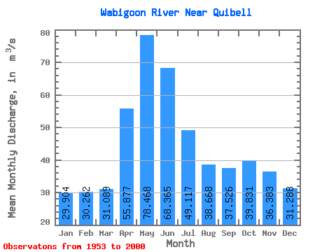
| Statistic | Jan | Feb | Mar | Apr | May | Jun | Jul | Aug | Sep | Oct | Nov | Dec | Annual |
|---|---|---|---|---|---|---|---|---|---|---|---|---|---|
| Mean | 29.90 | 30.26 | 31.09 | 55.88 | 78.47 | 68.36 | 49.12 | 38.67 | 37.53 | 39.83 | 36.38 | 31.29 | 43.90 |
| Standard Deviation | 8.95 | 8.38 | 8.09 | 20.52 | 55.93 | 38.95 | 24.64 | 21.04 | 31.04 | 25.36 | 19.99 | 11.70 | 15.27 |
| Min | 9.97 | 9.92 | 13.30 | 15.80 | 10.10 | 7.76 | 7.48 | 6.79 | 6.43 | 7.32 | 11.70 | 11.00 | 18.39 |
| Max | 51.90 | 49.30 | 52.10 | 103.00 | 235.00 | 198.00 | 146.00 | 109.00 | 211.00 | 113.00 | 114.00 | 75.20 | 83.02 |
| Coefficient of Variation | 0.30 | 0.28 | 0.26 | 0.37 | 0.71 | 0.57 | 0.50 | 0.54 | 0.83 | 0.64 | 0.55 | 0.37 | 0.35 |
 Return to R-Arctic Net Home Page