|
|
|||||||||||||||||
| Point ID: 4429 | Downloads | Plots | Site Data | Code: 05QA004 |
|
|
|||||||||||||||||
| Download | |
|---|---|
| Site Descriptor Information | Site Time Series Data |
| Link to all available data | |
| View: | Time Series | All |
| Units: | mm |
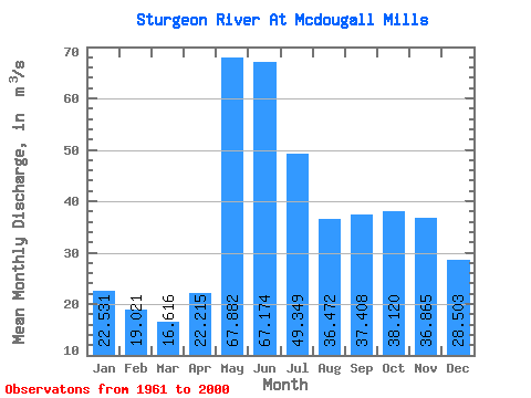
| Statistic | Jan | Feb | Mar | Apr | May | Jun | Jul | Aug | Sep | Oct | Nov | Dec | Annual |
|---|---|---|---|---|---|---|---|---|---|---|---|---|---|
| Mean | 22.53 | 19.02 | 16.62 | 22.21 | 67.88 | 67.17 | 49.35 | 36.47 | 37.41 | 38.12 | 36.87 | 28.50 | 37.01 |
| Standard Deviation | 9.29 | 6.53 | 4.69 | 7.74 | 34.91 | 33.69 | 19.95 | 15.85 | 28.12 | 26.70 | 25.60 | 14.83 | 12.44 |
| Min | 4.83 | 5.04 | 6.46 | 11.70 | 16.50 | 19.90 | 13.30 | 12.20 | 9.31 | 6.68 | 4.99 | 4.79 | 14.29 |
| Max | 43.90 | 32.20 | 26.00 | 44.30 | 177.00 | 160.00 | 106.00 | 79.80 | 128.00 | 100.00 | 134.00 | 67.10 | 70.03 |
| Coefficient of Variation | 0.41 | 0.34 | 0.28 | 0.35 | 0.51 | 0.50 | 0.40 | 0.43 | 0.75 | 0.70 | 0.69 | 0.52 | 0.34 |
 Return to R-Arctic Net Home Page