|
|
|||||||||||||||||
| Point ID: 4423 | Downloads | Plots | Site Data | Code: 05PE010 |
|
|
|||||||||||||||||
| Download | |
|---|---|
| Site Descriptor Information | Site Time Series Data |
| Link to all available data | |
| View: | Time Series | All |
| Units: | mm |
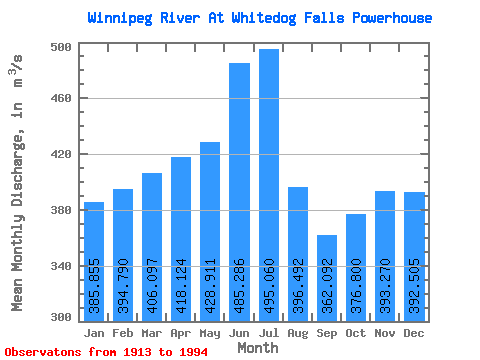
| Statistic | Jan | Feb | Mar | Apr | May | Jun | Jul | Aug | Sep | Oct | Nov | Dec | Annual |
|---|---|---|---|---|---|---|---|---|---|---|---|---|---|
| Mean | 385.86 | 394.79 | 406.10 | 418.12 | 428.91 | 485.29 | 495.06 | 396.49 | 362.09 | 376.80 | 393.27 | 392.50 | 415.16 |
| Standard Deviation | 157.48 | 156.77 | 161.74 | 176.96 | 259.53 | 342.00 | 322.27 | 233.05 | 178.67 | 179.91 | 194.75 | 173.28 | 148.99 |
| Min | 107.00 | 111.00 | 85.10 | 89.50 | 75.40 | 69.00 | 71.60 | 72.30 | 76.80 | 76.40 | 86.00 | 91.80 | 100.07 |
| Max | 781.00 | 763.00 | 828.00 | 971.00 | 1400.00 | 1540.00 | 1530.00 | 1170.00 | 827.00 | 1010.00 | 969.00 | 1000.00 | 815.67 |
| Coefficient of Variation | 0.41 | 0.40 | 0.40 | 0.42 | 0.60 | 0.70 | 0.65 | 0.59 | 0.49 | 0.48 | 0.49 | 0.44 | 0.36 |
 Return to R-Arctic Net Home Page