|
|
|||||||||||||||||
| Point ID: 4422 | Downloads | Plots | Site Data | Code: 05PE008 |
|
|
|||||||||||||||||
| Download | |
|---|---|
| Site Descriptor Information | Site Time Series Data |
| Link to all available data | |
| View: | Time Series | All |
| Units: | mm |
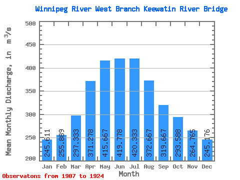
| Statistic | Jan | Feb | Mar | Apr | May | Jun | Jul | Aug | Sep | Oct | Nov | Dec | Annual |
|---|---|---|---|---|---|---|---|---|---|---|---|---|---|
| Mean | 245.61 | 255.89 | 297.33 | 371.28 | 415.67 | 419.78 | 420.33 | 372.67 | 319.67 | 293.59 | 264.76 | 245.18 | 335.25 |
| Standard Deviation | 99.66 | 110.22 | 121.25 | 153.97 | 208.22 | 237.59 | 265.70 | 228.71 | 168.60 | 152.37 | 126.26 | 108.62 | 122.65 |
| Min | 120.00 | 125.00 | 132.00 | 140.00 | 150.00 | 123.00 | 110.00 | 123.00 | 133.00 | 134.00 | 122.00 | 121.00 | 164.50 |
| Max | 527.00 | 503.00 | 570.00 | 594.00 | 872.00 | 1060.00 | 1130.00 | 990.00 | 801.00 | 686.00 | 581.00 | 541.00 | 668.50 |
| Coefficient of Variation | 0.41 | 0.43 | 0.41 | 0.41 | 0.50 | 0.57 | 0.63 | 0.61 | 0.53 | 0.52 | 0.48 | 0.44 | 0.37 |
 Return to R-Arctic Net Home Page