|
|
|||||||||||||||||
| Point ID: 4393 | Downloads | Plots | Site Data | Code: 05PB018 |
|
|
|||||||||||||||||
| Download | |
|---|---|
| Site Descriptor Information | Site Time Series Data |
| Link to all available data | |
| View: | Time Series | All |
| Units: | mm |
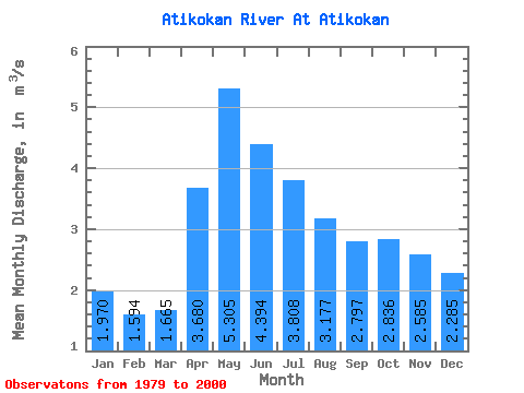
| Statistic | Jan | Feb | Mar | Apr | May | Jun | Jul | Aug | Sep | Oct | Nov | Dec | Annual |
|---|---|---|---|---|---|---|---|---|---|---|---|---|---|
| Mean | 1.97 | 1.59 | 1.67 | 3.68 | 5.30 | 4.39 | 3.81 | 3.18 | 2.80 | 2.84 | 2.58 | 2.29 | 2.96 |
| Standard Deviation | 0.93 | 0.64 | 0.62 | 1.22 | 2.54 | 2.15 | 2.17 | 1.73 | 2.05 | 1.96 | 1.60 | 1.36 | 1.05 |
| Min | 0.70 | 0.70 | 0.95 | 1.34 | 0.92 | 0.54 | 0.24 | 0.15 | 0.01 | 0.62 | 0.93 | 0.81 | 0.86 |
| Max | 4.40 | 3.40 | 3.59 | 5.46 | 10.10 | 9.01 | 9.49 | 6.68 | 8.66 | 9.69 | 7.73 | 6.25 | 5.09 |
| Coefficient of Variation | 0.47 | 0.40 | 0.38 | 0.33 | 0.48 | 0.49 | 0.57 | 0.54 | 0.73 | 0.69 | 0.62 | 0.59 | 0.35 |
 Return to R-Arctic Net Home Page