|
|
|||||||||||||||||
| Point ID: 4380 | Downloads | Plots | Site Data | Code: 04ME002 |
|
|
|||||||||||||||||
| Download | |
|---|---|
| Site Descriptor Information | Site Time Series Data |
| Link to all available data | |
| View: | Time Series | All |
| Units: | mm |
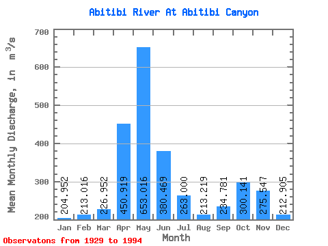
| Statistic | Jan | Feb | Mar | Apr | May | Jun | Jul | Aug | Sep | Oct | Nov | Dec | Annual |
|---|---|---|---|---|---|---|---|---|---|---|---|---|---|
| Mean | 204.95 | 213.02 | 226.95 | 450.92 | 653.02 | 380.47 | 263.00 | 213.22 | 234.78 | 300.14 | 275.55 | 212.91 | 300.03 |
| Standard Deviation | 39.84 | 43.94 | 50.58 | 162.35 | 291.68 | 167.94 | 98.93 | 53.17 | 77.82 | 128.63 | 98.97 | 44.93 | 45.76 |
| Min | 114.00 | 121.00 | 141.00 | 192.00 | 198.00 | 172.00 | 152.00 | 141.00 | 146.00 | 150.00 | 129.00 | 106.00 | 212.75 |
| Max | 309.00 | 392.00 | 394.00 | 898.00 | 1620.00 | 1040.00 | 688.00 | 407.00 | 591.00 | 710.00 | 713.00 | 368.00 | 424.17 |
| Coefficient of Variation | 0.19 | 0.21 | 0.22 | 0.36 | 0.45 | 0.44 | 0.38 | 0.25 | 0.33 | 0.43 | 0.36 | 0.21 | 0.15 |
 Return to R-Arctic Net Home Page