|
|
|||||||||||||||||
| Point ID: 4365 | Downloads | Plots | Site Data | Code: 04LF001 |
|
|
|||||||||||||||||
| Download | |
|---|---|
| Site Descriptor Information | Site Time Series Data |
| Link to all available data | |
| View: | Time Series | All |
| Units: | mm |
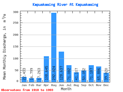
| Statistic | Jan | Feb | Mar | Apr | May | Jun | Jul | Aug | Sep | Oct | Nov | Dec | Annual |
|---|---|---|---|---|---|---|---|---|---|---|---|---|---|
| Mean | 22.43 | 16.80 | 17.26 | 108.64 | 292.02 | 128.64 | 71.08 | 41.11 | 50.05 | 71.19 | 65.89 | 39.02 | 76.80 |
| Standard Deviation | 7.00 | 4.30 | 7.06 | 64.83 | 101.25 | 56.59 | 38.26 | 21.59 | 36.83 | 47.08 | 33.15 | 16.56 | 17.01 |
| Min | 6.19 | 5.40 | 8.35 | 12.20 | 77.80 | 44.40 | 21.40 | 5.40 | 6.24 | 13.60 | 12.30 | 5.51 | 43.67 |
| Max | 46.30 | 28.90 | 49.00 | 289.00 | 546.00 | 330.00 | 184.00 | 96.50 | 193.00 | 230.00 | 176.00 | 96.00 | 143.05 |
| Coefficient of Variation | 0.31 | 0.26 | 0.41 | 0.60 | 0.35 | 0.44 | 0.54 | 0.53 | 0.74 | 0.66 | 0.50 | 0.42 | 0.22 |
 Return to R-Arctic Net Home Page