|
|
|||||||||||||||||
| Point ID: 4358 | Downloads | Plots | Site Data | Code: 04KA001 |
|
|
|||||||||||||||||
| Download | |
|---|---|
| Site Descriptor Information | Site Time Series Data |
| Link to all available data | |
| View: | Time Series | All |
| Units: | mm |
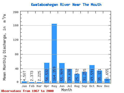
| Statistic | Jan | Feb | Mar | Apr | May | Jun | Jul | Aug | Sep | Oct | Nov | Dec | Annual |
|---|---|---|---|---|---|---|---|---|---|---|---|---|---|
| Mean | 4.51 | 2.37 | 2.23 | 56.53 | 164.36 | 55.91 | 39.64 | 25.57 | 31.25 | 49.59 | 35.12 | 11.65 | 40.59 |
| Standard Deviation | 3.63 | 1.79 | 2.86 | 52.32 | 65.19 | 35.89 | 28.24 | 27.11 | 29.99 | 31.57 | 16.49 | 7.73 | 11.85 |
| Min | 0.96 | 0.80 | 0.47 | 1.46 | 41.80 | 16.60 | 6.51 | 1.86 | 2.77 | 7.93 | 8.54 | 2.48 | 16.31 |
| Max | 21.00 | 10.10 | 16.90 | 165.00 | 318.00 | 146.00 | 110.00 | 115.00 | 133.00 | 175.00 | 78.90 | 42.90 | 64.81 |
| Coefficient of Variation | 0.81 | 0.75 | 1.28 | 0.93 | 0.40 | 0.64 | 0.71 | 1.06 | 0.96 | 0.64 | 0.47 | 0.66 | 0.29 |
 Return to R-Arctic Net Home Page