|
|
|||||||||||||||||
| Point ID: 435 | Downloads | Plots | Site Data | Code: 05CK002 |
|
|
|||||||||||||||||
| Download | |
|---|---|
| Site Descriptor Information | Site Time Series Data |
| Link to all available data | |
| View: | Time Series | All |
| Units: | mm |
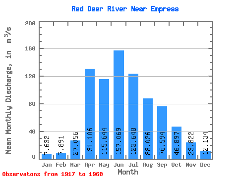
| Statistic | Jan | Feb | Mar | Apr | May | Jun | Jul | Aug | Sep | Oct | Nov | Dec | Annual |
|---|---|---|---|---|---|---|---|---|---|---|---|---|---|
| Mean | 7.63 | 7.89 | 27.06 | 131.11 | 115.64 | 157.07 | 123.65 | 88.03 | 76.59 | 46.90 | 23.82 | 12.13 | 70.28 |
| Standard Deviation | 4.76 | 4.65 | 32.63 | 96.38 | 112.92 | 95.50 | 61.04 | 46.30 | 74.70 | 26.82 | 15.34 | 7.50 | 28.79 |
| Min | 1.64 | 0.98 | 3.20 | 20.20 | 34.50 | 52.70 | 45.10 | 51.90 | 27.00 | 19.40 | 8.08 | 3.23 | 36.71 |
| Max | 20.30 | 18.60 | 140.00 | 412.00 | 591.00 | 475.00 | 358.00 | 282.00 | 362.00 | 135.00 | 66.60 | 28.80 | 136.93 |
| Coefficient of Variation | 0.62 | 0.59 | 1.21 | 0.73 | 0.98 | 0.61 | 0.49 | 0.53 | 0.97 | 0.57 | 0.64 | 0.62 | 0.41 |
 Return to R-Arctic Net Home Page