|
|
|||||||||||||||||
| Point ID: 4342 | Downloads | Plots | Site Data | Code: 04GB005 |
|
|
|||||||||||||||||
| Download | |
|---|---|
| Site Descriptor Information | Site Time Series Data |
| Link to all available data | |
| View: | Time Series | All |
| Units: | mm |
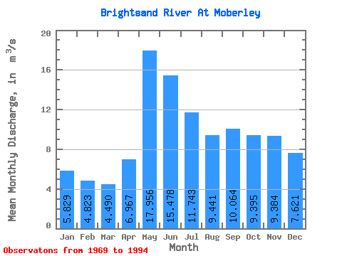
| Statistic | Jan | Feb | Mar | Apr | May | Jun | Jul | Aug | Sep | Oct | Nov | Dec | Annual |
|---|---|---|---|---|---|---|---|---|---|---|---|---|---|
| Mean | 5.83 | 4.82 | 4.49 | 6.97 | 17.96 | 15.48 | 11.74 | 9.44 | 10.06 | 9.39 | 9.38 | 7.62 | 9.40 |
| Standard Deviation | 1.33 | 0.91 | 0.70 | 2.19 | 8.32 | 7.86 | 4.47 | 6.59 | 7.78 | 5.53 | 5.75 | 2.38 | 2.37 |
| Min | 3.25 | 3.00 | 2.95 | 3.98 | 3.85 | 5.17 | 3.15 | 3.00 | 1.83 | 0.50 | 1.29 | 3.27 | 4.66 |
| Max | 8.68 | 6.83 | 5.51 | 11.70 | 31.10 | 35.10 | 20.30 | 31.90 | 31.40 | 24.30 | 28.10 | 13.70 | 13.04 |
| Coefficient of Variation | 0.23 | 0.19 | 0.15 | 0.31 | 0.46 | 0.51 | 0.38 | 0.70 | 0.77 | 0.59 | 0.61 | 0.31 | 0.25 |
 Return to R-Arctic Net Home Page