|
|
|||||||||||||||||
| Point ID: 4338 | Downloads | Plots | Site Data | Code: 04GA002 |
|
|
|||||||||||||||||
| Download | |
|---|---|
| Site Descriptor Information | Site Time Series Data |
| Link to all available data | |
| View: | Time Series | All |
| Units: | mm |
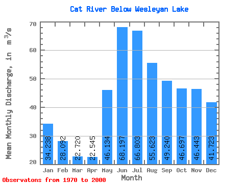
| Statistic | Jan | Feb | Mar | Apr | May | Jun | Jul | Aug | Sep | Oct | Nov | Dec | Annual |
|---|---|---|---|---|---|---|---|---|---|---|---|---|---|
| Mean | 34.24 | 28.09 | 22.72 | 22.55 | 46.13 | 68.20 | 66.80 | 55.62 | 49.24 | 46.70 | 46.44 | 41.72 | 43.63 |
| Standard Deviation | 12.15 | 8.70 | 6.14 | 5.93 | 21.04 | 41.33 | 32.02 | 23.00 | 21.95 | 20.19 | 19.59 | 16.11 | 13.70 |
| Min | 10.40 | 9.98 | 9.39 | 10.30 | 17.90 | 19.10 | 20.40 | 24.70 | 18.80 | 13.40 | 11.50 | 10.90 | 19.81 |
| Max | 59.40 | 44.70 | 34.30 | 33.00 | 103.00 | 201.00 | 156.00 | 115.00 | 112.00 | 89.10 | 86.70 | 76.50 | 80.86 |
| Coefficient of Variation | 0.35 | 0.31 | 0.27 | 0.26 | 0.46 | 0.61 | 0.48 | 0.41 | 0.45 | 0.43 | 0.42 | 0.39 | 0.31 |
 Return to R-Arctic Net Home Page