|
|
|||||||||||||||||
| Point ID: 4337 | Downloads | Plots | Site Data | Code: 04FC001 |
|
|
|||||||||||||||||
| Download | |
|---|---|
| Site Descriptor Information | Site Time Series Data |
| Link to all available data | |
| View: | Time Series | All |
| Units: | mm |
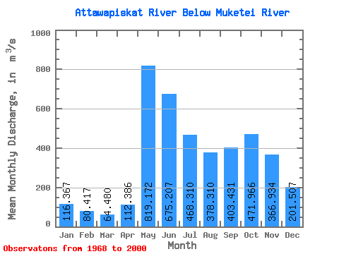
| Statistic | Jan | Feb | Mar | Apr | May | Jun | Jul | Aug | Sep | Oct | Nov | Dec | Annual |
|---|---|---|---|---|---|---|---|---|---|---|---|---|---|
| Mean | 116.37 | 80.42 | 64.48 | 112.39 | 819.17 | 675.21 | 468.31 | 378.31 | 403.43 | 471.97 | 366.93 | 201.51 | 346.22 |
| Standard Deviation | 39.48 | 22.20 | 14.95 | 65.33 | 337.10 | 330.15 | 231.24 | 240.53 | 253.74 | 262.90 | 186.54 | 88.63 | 106.36 |
| Min | 58.80 | 49.00 | 44.50 | 48.00 | 321.00 | 198.00 | 158.00 | 119.00 | 78.70 | 104.00 | 79.10 | 52.70 | 176.39 |
| Max | 198.00 | 122.00 | 104.00 | 326.00 | 1810.00 | 1770.00 | 1230.00 | 1100.00 | 855.00 | 1030.00 | 812.00 | 441.00 | 544.55 |
| Coefficient of Variation | 0.34 | 0.28 | 0.23 | 0.58 | 0.41 | 0.49 | 0.49 | 0.64 | 0.63 | 0.56 | 0.51 | 0.44 | 0.31 |
 Return to R-Arctic Net Home Page