|
|
|||||||||||||||||
| Point ID: 4330 | Downloads | Plots | Site Data | Code: 04DC001 |
|
|
|||||||||||||||||
| Download | |
|---|---|
| Site Descriptor Information | Site Time Series Data |
| Link to all available data | |
| View: | Time Series | All |
| Units: | mm |
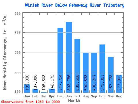
| Statistic | Jan | Feb | Mar | Apr | May | Jun | Jul | Aug | Sep | Oct | Nov | Dec | Annual |
|---|---|---|---|---|---|---|---|---|---|---|---|---|---|
| Mean | 185.83 | 137.90 | 108.50 | 142.17 | 747.72 | 803.79 | 635.59 | 500.83 | 498.21 | 579.37 | 457.73 | 277.90 | 418.92 |
| Standard Deviation | 57.30 | 36.07 | 22.94 | 93.46 | 442.11 | 445.93 | 316.33 | 245.75 | 213.73 | 293.49 | 208.42 | 93.88 | 145.80 |
| Min | 84.60 | 74.60 | 66.20 | 74.20 | 203.00 | 249.00 | 208.00 | 167.00 | 132.00 | 135.00 | 131.00 | 102.00 | 191.49 |
| Max | 289.00 | 202.00 | 155.00 | 434.00 | 2230.00 | 2440.00 | 1490.00 | 1240.00 | 829.00 | 1480.00 | 1020.00 | 450.00 | 803.42 |
| Coefficient of Variation | 0.31 | 0.26 | 0.21 | 0.66 | 0.59 | 0.56 | 0.50 | 0.49 | 0.43 | 0.51 | 0.46 | 0.34 | 0.35 |
 Return to R-Arctic Net Home Page