|
|
|||||||||||||||||
| Point ID: 4326 | Downloads | Plots | Site Data | Code: 04DA001 |
|
|
|||||||||||||||||
| Download | |
|---|---|
| Site Descriptor Information | Site Time Series Data |
| Link to all available data | |
| View: | Time Series | All |
| Units: | mm |
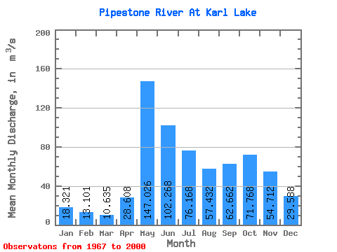
| Statistic | Jan | Feb | Mar | Apr | May | Jun | Jul | Aug | Sep | Oct | Nov | Dec | Annual |
|---|---|---|---|---|---|---|---|---|---|---|---|---|---|
| Mean | 18.32 | 13.10 | 10.63 | 28.61 | 147.03 | 102.27 | 76.17 | 57.43 | 62.66 | 71.77 | 54.71 | 29.59 | 56.02 |
| Standard Deviation | 6.50 | 3.99 | 3.14 | 21.28 | 71.14 | 60.92 | 38.87 | 37.48 | 43.74 | 42.59 | 26.61 | 14.32 | 18.94 |
| Min | 9.34 | 6.43 | 5.73 | 8.03 | 38.10 | 27.30 | 15.00 | 13.10 | 11.50 | 14.00 | 18.00 | 11.70 | 30.42 |
| Max | 38.90 | 22.30 | 17.70 | 84.40 | 366.00 | 304.00 | 162.00 | 151.00 | 185.00 | 209.00 | 111.00 | 88.90 | 97.15 |
| Coefficient of Variation | 0.35 | 0.30 | 0.30 | 0.74 | 0.48 | 0.60 | 0.51 | 0.65 | 0.70 | 0.59 | 0.49 | 0.48 | 0.34 |
 Return to R-Arctic Net Home Page