|
|
|||||||||||||||||
| Point ID: 4322 | Downloads | Plots | Site Data | Code: 04CC001 |
|
|
|||||||||||||||||
| Download | |
|---|---|
| Site Descriptor Information | Site Time Series Data |
| Link to all available data | |
| View: | Time Series | All |
| Units: | mm |
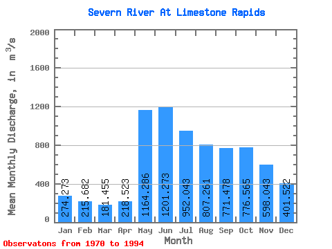
| Statistic | Jan | Feb | Mar | Apr | May | Jun | Jul | Aug | Sep | Oct | Nov | Dec | Annual |
|---|---|---|---|---|---|---|---|---|---|---|---|---|---|
| Mean | 274.27 | 215.68 | 181.46 | 218.52 | 1164.29 | 1201.27 | 952.04 | 807.26 | 771.48 | 776.57 | 598.04 | 401.52 | 631.20 |
| Standard Deviation | 76.59 | 58.71 | 46.80 | 144.98 | 472.94 | 585.01 | 403.68 | 346.66 | 261.01 | 256.60 | 183.40 | 122.72 | 174.91 |
| Min | 130.00 | 114.00 | 102.00 | 97.50 | 157.00 | 312.00 | 422.00 | 371.00 | 371.00 | 376.00 | 215.00 | 158.00 | 377.96 |
| Max | 468.00 | 358.00 | 284.00 | 804.00 | 2000.00 | 2530.00 | 2120.00 | 1850.00 | 1410.00 | 1330.00 | 988.00 | 665.00 | 1036.50 |
| Coefficient of Variation | 0.28 | 0.27 | 0.26 | 0.66 | 0.41 | 0.49 | 0.42 | 0.43 | 0.34 | 0.33 | 0.31 | 0.31 | 0.28 |
 Return to R-Arctic Net Home Page