|
|
|||||||||||||||||
| Point ID: 4320 | Downloads | Plots | Site Data | Code: 04CA004 |
|
|
|||||||||||||||||
| Download | |
|---|---|
| Site Descriptor Information | Site Time Series Data |
| Link to all available data | |
| View: | Time Series | All |
| Units: | mm |
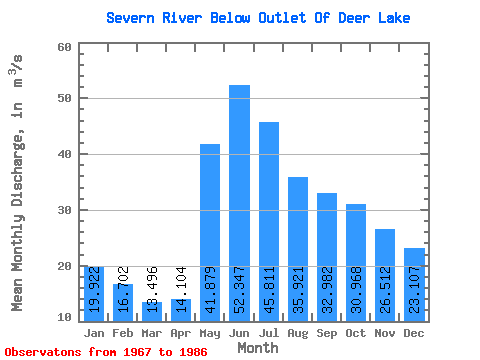
| Statistic | Jan | Feb | Mar | Apr | May | Jun | Jul | Aug | Sep | Oct | Nov | Dec | Annual |
|---|---|---|---|---|---|---|---|---|---|---|---|---|---|
| Mean | 19.92 | 16.70 | 13.50 | 14.10 | 41.88 | 52.35 | 45.81 | 35.92 | 32.98 | 30.97 | 26.51 | 23.11 | 29.80 |
| Standard Deviation | 9.64 | 6.26 | 3.59 | 3.71 | 16.77 | 20.30 | 19.11 | 18.95 | 24.95 | 27.78 | 19.05 | 13.67 | 11.31 |
| Min | 3.70 | 4.08 | 4.34 | 5.62 | 16.50 | 17.00 | 19.30 | 12.70 | 7.26 | 4.40 | 3.22 | 3.23 | 16.02 |
| Max | 49.60 | 33.30 | 19.90 | 20.40 | 70.10 | 90.80 | 77.90 | 82.60 | 107.00 | 126.00 | 85.80 | 66.70 | 62.72 |
| Coefficient of Variation | 0.48 | 0.38 | 0.27 | 0.26 | 0.40 | 0.39 | 0.42 | 0.53 | 0.76 | 0.90 | 0.72 | 0.59 | 0.38 |
 Return to R-Arctic Net Home Page