|
|
|||||||||||||||||
| Point ID: 425 | Downloads | Plots | Site Data | Code: 05CJ004 |
|
|
|||||||||||||||||
| Download | |
|---|---|
| Site Descriptor Information | Site Time Series Data |
| Link to all available data | |
| View: | Time Series | All |
| Units: | mm |
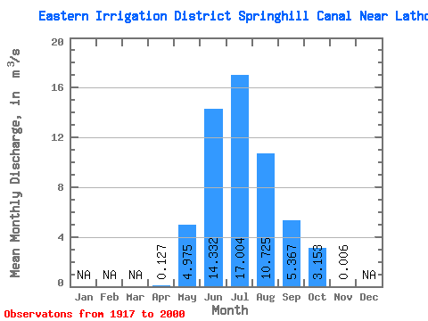
| Statistic | Jan | Feb | Mar | Apr | May | Jun | Jul | Aug | Sep | Oct | Nov | Dec | Annual |
|---|---|---|---|---|---|---|---|---|---|---|---|---|---|
| Mean | 0.13 | 4.97 | 14.33 | 17.00 | 10.72 | 5.37 | 3.15 | 0.01 | |||||
| Standard Deviation | 0.31 | 3.77 | 5.52 | 5.64 | 3.16 | 2.38 | 1.85 | 0.05 | |||||
| Min | 0.00 | 0.14 | 0.61 | 3.72 | 2.21 | 0.00 | 0.00 | 0.00 | |||||
| Max | 1.82 | 18.70 | 25.50 | 27.80 | 16.50 | 10.40 | 7.69 | 0.42 | |||||
| Coefficient of Variation | 2.42 | 0.76 | 0.39 | 0.33 | 0.29 | 0.44 | 0.59 | 7.74 |
 Return to R-Arctic Net Home Page