|
|
|||||||||||||||||
| Point ID: 421 | Downloads | Plots | Site Data | Code: 05CH016 |
|
|
|||||||||||||||||
| Download | |
|---|---|
| Site Descriptor Information | Site Time Series Data |
| Link to all available data | |
| View: | Time Series | All |
| Units: | mm |
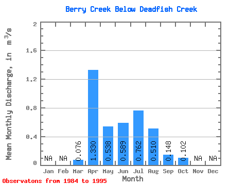
| Statistic | Jan | Feb | Mar | Apr | May | Jun | Jul | Aug | Sep | Oct | Nov | Dec | Annual |
|---|---|---|---|---|---|---|---|---|---|---|---|---|---|
| Mean | 0.08 | 1.33 | 0.54 | 0.59 | 0.76 | 0.51 | 0.15 | 0.10 | |||||
| Standard Deviation | 0.10 | 3.07 | 0.31 | 0.23 | 0.25 | 0.27 | 0.16 | 0.07 | |||||
| Min | 0.00 | 0.01 | 0.00 | 0.00 | 0.26 | 0.21 | 0.02 | 0.02 | |||||
| Max | 0.26 | 9.62 | 1.03 | 0.84 | 1.10 | 1.11 | 0.58 | 0.26 | |||||
| Coefficient of Variation | 1.24 | 2.31 | 0.58 | 0.38 | 0.33 | 0.53 | 1.08 | 0.64 |
 Return to R-Arctic Net Home Page