|
|
|||||||||||||||||
| Point ID: 406 | Downloads | Plots | Site Data | Code: 05CG003 |
|
|
|||||||||||||||||
| Download | |
|---|---|
| Site Descriptor Information | Site Time Series Data |
| Link to all available data | |
| View: | Time Series | All |
| Units: | mm |
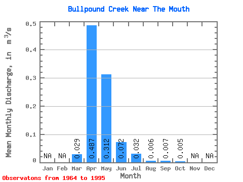
| Statistic | Jan | Feb | Mar | Apr | May | Jun | Jul | Aug | Sep | Oct | Nov | Dec | Annual |
|---|---|---|---|---|---|---|---|---|---|---|---|---|---|
| Mean | 0.03 | 0.49 | 0.31 | 0.07 | 0.03 | 0.01 | 0.01 | 0.01 | |||||
| Standard Deviation | 0.10 | 1.64 | 0.98 | 0.22 | 0.14 | 0.02 | 0.03 | 0.03 | |||||
| Min | 0.00 | 0.00 | 0.00 | 0.00 | 0.00 | 0.00 | 0.00 | 0.00 | |||||
| Max | 0.50 | 9.07 | 4.10 | 1.17 | 0.80 | 0.07 | 0.16 | 0.14 | |||||
| Coefficient of Variation | 3.53 | 3.36 | 3.13 | 3.11 | 4.48 | 3.29 | 4.19 | 5.42 |
 Return to R-Arctic Net Home Page