|
|
|||||||||||||||||
| Point ID: 403 | Downloads | Plots | Site Data | Code: 05CE020 |
|
|
|||||||||||||||||
| Download | |
|---|---|
| Site Descriptor Information | Site Time Series Data |
| Link to all available data | |
| View: | Time Series | All |
| Units: | mm |
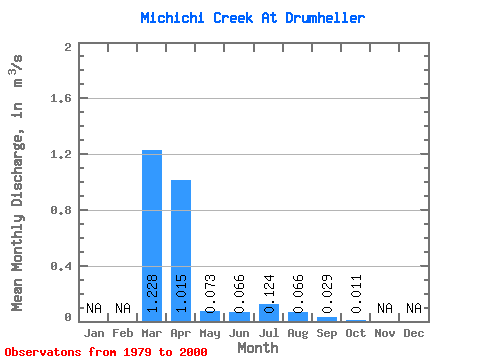
| Statistic | Jan | Feb | Mar | Apr | May | Jun | Jul | Aug | Sep | Oct | Nov | Dec | Annual |
|---|---|---|---|---|---|---|---|---|---|---|---|---|---|
| Mean | 1.23 | 1.01 | 0.07 | 0.07 | 0.12 | 0.07 | 0.03 | 0.01 | |||||
| Standard Deviation | 1.86 | 1.36 | 0.06 | 0.06 | 0.31 | 0.10 | 0.05 | 0.04 | |||||
| Min | 0.02 | 0.00 | 0.00 | 0.00 | 0.00 | 0.00 | 0.00 | 0.00 | |||||
| Max | 6.88 | 3.93 | 0.20 | 0.20 | 1.43 | 0.35 | 0.22 | 0.18 | |||||
| Coefficient of Variation | 1.52 | 1.34 | 0.80 | 0.93 | 2.49 | 1.46 | 1.73 | 3.48 |
 Return to R-Arctic Net Home Page