|
|
|||||||||||||||||
| Point ID: 387 | Downloads | Plots | Site Data | Code: 05CE002 |
|
|
|||||||||||||||||
| Download | |
|---|---|
| Site Descriptor Information | Site Time Series Data |
| Link to all available data | |
| View: | Time Series | All |
| Units: | mm |
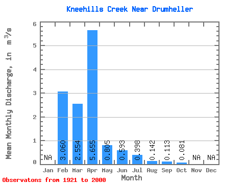
| Statistic | Jan | Feb | Mar | Apr | May | Jun | Jul | Aug | Sep | Oct | Nov | Dec | Annual |
|---|---|---|---|---|---|---|---|---|---|---|---|---|---|
| Mean | 3.06 | 2.55 | 5.66 | 0.81 | 0.59 | 0.40 | 0.14 | 0.11 | 0.08 | ||||
| Standard Deviation | 3.77 | 9.07 | 1.45 | 1.04 | 0.72 | 0.15 | 0.16 | 0.17 | |||||
| Min | 3.06 | 0.00 | 0.09 | 0.00 | 0.00 | 0.00 | 0.00 | 0.00 | 0.00 | ||||
| Max | 3.06 | 16.20 | 38.00 | 7.98 | 5.19 | 4.23 | 0.82 | 0.56 | 1.21 | ||||
| Coefficient of Variation | 1.48 | 1.60 | 1.81 | 1.76 | 1.82 | 1.08 | 1.43 | 2.15 |
 Return to R-Arctic Net Home Page