|
|
|||||||||||||||||
| Point ID: 372 | Downloads | Plots | Site Data | Code: 05CC001 |
|
|
|||||||||||||||||
| Download | |
|---|---|
| Site Descriptor Information | Site Time Series Data |
| Link to all available data | |
| View: | Time Series | All |
| Units: | mm |
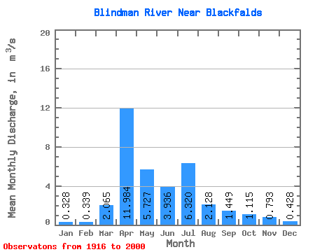
| Statistic | Jan | Feb | Mar | Apr | May | Jun | Jul | Aug | Sep | Oct | Nov | Dec | Annual |
|---|---|---|---|---|---|---|---|---|---|---|---|---|---|
| Mean | 0.33 | 0.34 | 2.06 | 11.98 | 5.73 | 3.94 | 6.32 | 2.13 | 1.45 | 1.11 | 0.79 | 0.43 | 3.11 |
| Standard Deviation | 0.28 | 0.28 | 2.37 | 9.98 | 9.25 | 4.44 | 9.01 | 2.95 | 2.72 | 1.31 | 0.75 | 0.32 | 1.91 |
| Min | 0.03 | 0.04 | 0.08 | 0.84 | 0.13 | 0.34 | 0.09 | 0.04 | 0.03 | 0.03 | 0.20 | 0.08 | 0.77 |
| Max | 1.64 | 1.33 | 8.16 | 42.20 | 59.30 | 19.50 | 38.30 | 13.60 | 18.00 | 8.43 | 4.65 | 1.84 | 8.10 |
| Coefficient of Variation | 0.87 | 0.84 | 1.15 | 0.83 | 1.62 | 1.13 | 1.43 | 1.38 | 1.88 | 1.18 | 0.95 | 0.74 | 0.61 |
 Return to R-Arctic Net Home Page