|
|
|||||||||||||||||
| Point ID: 3691 | Downloads | Plots | Site Data | Code: 10UB001 |
|
|
|||||||||||||||||
| Download | |
|---|---|
| Site Descriptor Information | Site Time Series Data |
| Link to all available data | |
| View: | Time Series | All |
| Units: | mm |
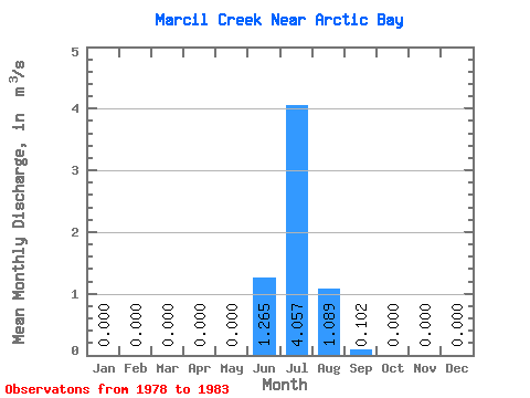
| Statistic | Jan | Feb | Mar | Apr | May | Jun | Jul | Aug | Sep | Oct | Nov | Dec | Annual |
|---|---|---|---|---|---|---|---|---|---|---|---|---|---|
| Mean | 0.00 | 0.00 | 0.00 | 0.00 | 0.00 | 1.27 | 4.06 | 1.09 | 0.10 | 0.00 | 0.00 | 0.00 | 0.54 |
| Standard Deviation | 0.00 | 0.00 | 0.00 | 0.00 | 0.00 | 1.28 | 1.71 | 0.62 | 0.06 | 0.00 | 0.00 | 0.00 | 0.07 |
| Min | 0.00 | 0.00 | 0.00 | 0.00 | 0.00 | 0.15 | 2.39 | 0.54 | 0.03 | 0.00 | 0.00 | 0.00 | 0.46 |
| Max | 0.00 | 0.00 | 0.00 | 0.00 | 0.00 | 2.66 | 5.80 | 1.76 | 0.15 | 0.00 | 0.00 | 0.00 | 0.59 |
| Coefficient of Variation | 1.01 | 0.42 | 0.57 | 0.62 | 0.13 |
 Return to R-Arctic Net Home Page