|
|
|||||||||||||||||
| Point ID: 369 | Downloads | Plots | Site Data | Code: 05CB004 |
|
|
|||||||||||||||||
| Download | |
|---|---|
| Site Descriptor Information | Site Time Series Data |
| Link to all available data | |
| View: | Time Series | All |
| Units: | mm |
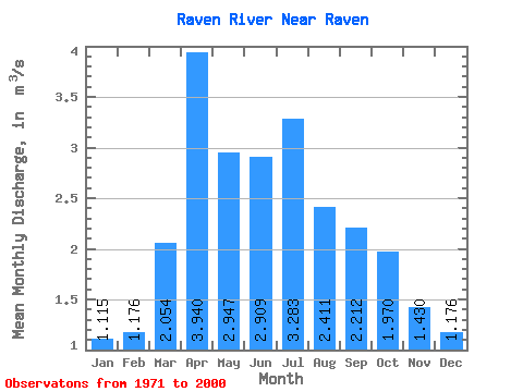
| Statistic | Jan | Feb | Mar | Apr | May | Jun | Jul | Aug | Sep | Oct | Nov | Dec | Annual |
|---|---|---|---|---|---|---|---|---|---|---|---|---|---|
| Mean | 1.11 | 1.18 | 2.05 | 3.94 | 2.95 | 2.91 | 3.28 | 2.41 | 2.21 | 1.97 | 1.43 | 1.18 | 2.22 |
| Standard Deviation | 0.19 | 0.26 | 0.81 | 1.77 | 1.24 | 1.55 | 2.20 | 0.84 | 0.67 | 0.60 | 0.31 | 0.20 | 0.47 |
| Min | 0.84 | 0.78 | 1.08 | 1.69 | 1.40 | 1.44 | 0.97 | 1.04 | 1.35 | 1.06 | 0.84 | 0.80 | 1.29 |
| Max | 1.72 | 2.04 | 4.12 | 8.55 | 6.78 | 8.97 | 11.70 | 4.79 | 4.52 | 4.58 | 2.34 | 1.65 | 3.45 |
| Coefficient of Variation | 0.17 | 0.23 | 0.39 | 0.45 | 0.42 | 0.53 | 0.67 | 0.35 | 0.30 | 0.31 | 0.22 | 0.17 | 0.21 |
 Return to R-Arctic Net Home Page