|
|
|||||||||||||||||
| Point ID: 3682 | Downloads | Plots | Site Data | Code: 10QC002 |
|
|
|||||||||||||||||
| Download | |
|---|---|
| Site Descriptor Information | Site Time Series Data |
| Link to all available data | |
| View: | Time Series | All |
| Units: | mm |
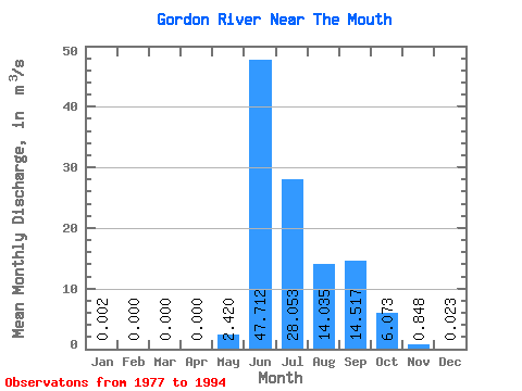
| Statistic | Jan | Feb | Mar | Apr | May | Jun | Jul | Aug | Sep | Oct | Nov | Dec | Annual |
|---|---|---|---|---|---|---|---|---|---|---|---|---|---|
| Mean | 0.00 | 0.00 | 0.00 | 0.00 | 2.42 | 47.71 | 28.05 | 14.04 | 14.52 | 6.07 | 0.85 | 0.02 | 9.04 |
| Standard Deviation | 0.01 | 0.00 | 0.00 | 0.00 | 6.56 | 19.45 | 11.46 | 6.83 | 7.65 | 3.16 | 0.55 | 0.04 | 1.78 |
| Min | 0.00 | 0.00 | 0.00 | 0.00 | 0.00 | 13.20 | 12.20 | 7.48 | 3.68 | 1.71 | 0.01 | 0.00 | 6.11 |
| Max | 0.02 | 0.00 | 0.00 | 0.00 | 26.50 | 85.90 | 50.00 | 30.50 | 32.00 | 12.50 | 1.99 | 0.13 | 12.84 |
| Coefficient of Variation | 3.32 | 2.71 | 0.41 | 0.41 | 0.49 | 0.53 | 0.52 | 0.65 | 1.74 | 0.20 |
 Return to R-Arctic Net Home Page