|
|
|||||||||||||||||
| Point ID: 3679 | Downloads | Plots | Site Data | Code: 10PC004 |
|
|
|||||||||||||||||
| Download | |
|---|---|
| Site Descriptor Information | Site Time Series Data |
| Link to all available data | |
| View: | Time Series | All |
| Units: | mm |
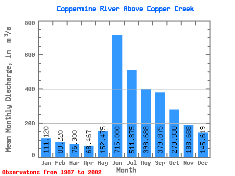
| Statistic | Jan | Feb | Mar | Apr | May | Jun | Jul | Aug | Sep | Oct | Nov | Dec | Annual |
|---|---|---|---|---|---|---|---|---|---|---|---|---|---|
| Mean | 111.12 | 89.22 | 76.30 | 68.47 | 152.47 | 715.00 | 511.88 | 398.69 | 379.88 | 279.94 | 188.69 | 145.62 | 263.32 |
| Standard Deviation | 23.18 | 18.46 | 16.08 | 14.02 | 156.53 | 246.99 | 176.03 | 128.89 | 124.03 | 92.16 | 46.27 | 33.40 | 62.13 |
| Min | 68.80 | 57.40 | 50.40 | 45.10 | 43.00 | 312.00 | 313.00 | 230.00 | 241.00 | 185.00 | 119.00 | 77.90 | 178.86 |
| Max | 155.00 | 131.00 | 116.00 | 104.00 | 590.00 | 1180.00 | 932.00 | 709.00 | 696.00 | 573.00 | 286.00 | 201.00 | 367.52 |
| Coefficient of Variation | 0.21 | 0.21 | 0.21 | 0.20 | 1.03 | 0.34 | 0.34 | 0.32 | 0.33 | 0.33 | 0.24 | 0.23 | 0.24 |
 Return to R-Arctic Net Home Page