|
|
|||||||||||||||||
| Point ID: 3643 | Downloads | Plots | Site Data | Code: 10KA003 |
|
|
|||||||||||||||||
| Download | |
|---|---|
| Site Descriptor Information | Site Time Series Data |
| Link to all available data | |
| View: | Time Series | All |
| Units: | mm |
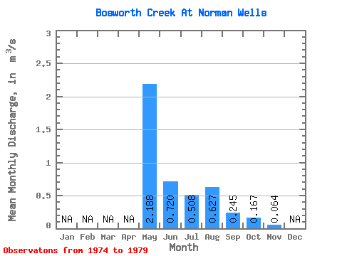
| Statistic | Jan | Feb | Mar | Apr | May | Jun | Jul | Aug | Sep | Oct | Nov | Dec | Annual |
|---|---|---|---|---|---|---|---|---|---|---|---|---|---|
| Mean | 2.19 | 0.72 | 0.51 | 0.63 | 0.24 | 0.17 | 0.06 | ||||||
| Standard Deviation | 0.80 | 0.44 | 0.32 | 0.94 | 0.08 | 0.05 | |||||||
| Min | 1.09 | 0.35 | 0.24 | 0.14 | 0.12 | 0.13 | 0.06 | ||||||
| Max | 3.01 | 1.36 | 1.06 | 2.53 | 0.31 | 0.20 | 0.06 | ||||||
| Coefficient of Variation | 0.37 | 0.61 | 0.63 | 1.49 | 0.31 | 0.28 |
 Return to R-Arctic Net Home Page