|
|
|||||||||||||||||
| Point ID: 3639 | Downloads | Plots | Site Data | Code: 10JD001 |
|
|
|||||||||||||||||
| Download | |
|---|---|
| Site Descriptor Information | Site Time Series Data |
| Link to all available data | |
| View: | Time Series | All |
| Units: | mm |
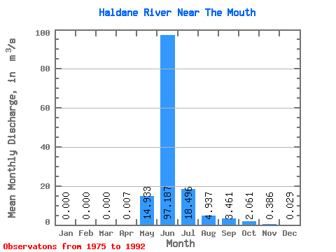
| Statistic | Jan | Feb | Mar | Apr | May | Jun | Jul | Aug | Sep | Oct | Nov | Dec | Annual |
|---|---|---|---|---|---|---|---|---|---|---|---|---|---|
| Mean | 0.00 | 0.00 | 0.00 | 0.01 | 14.93 | 97.19 | 18.50 | 4.94 | 3.46 | 2.06 | 0.39 | 0.03 | 12.01 |
| Standard Deviation | 0.00 | 0.00 | 0.00 | 0.03 | 18.61 | 37.59 | 5.84 | 3.46 | 3.54 | 2.30 | 0.45 | 0.06 | 4.72 |
| Min | 0.00 | 0.00 | 0.00 | 0.00 | 0.00 | 48.40 | 9.13 | 1.05 | 0.85 | 0.15 | 0.00 | 0.00 | 5.32 |
| Max | 0.00 | 0.00 | 0.00 | 0.09 | 52.40 | 151.00 | 32.70 | 16.00 | 13.20 | 9.12 | 1.59 | 0.22 | 17.63 |
| Coefficient of Variation | 3.46 | 1.25 | 0.39 | 0.32 | 0.70 | 1.02 | 1.12 | 1.18 | 2.18 | 0.39 |
 Return to R-Arctic Net Home Page