|
|
|||||||||||||||||
| Point ID: 3622 | Downloads | Plots | Site Data | Other Close Sites | Code: 10GC001 |
|
|
|||||||||||||||||
| Download | |
|---|---|
| Site Descriptor Information | Site Time Series Data |
| Link to all available data | |
| View: | Time Series | All |
| Units: | mm |
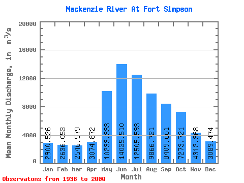
| Statistic | Jan | Feb | Mar | Apr | May | Jun | Jul | Aug | Sep | Oct | Nov | Dec | Annual |
|---|---|---|---|---|---|---|---|---|---|---|---|---|---|
| Mean | 2900.53 | 2636.05 | 2546.58 | 3074.87 | 10233.33 | 14035.51 | 12505.59 | 9866.72 | 8409.66 | 7273.72 | 4312.37 | 3089.47 | 6768.85 |
| Standard Deviation | 600.63 | 587.90 | 575.01 | 785.38 | 1959.91 | 2503.68 | 2345.70 | 1927.84 | 1754.54 | 1323.30 | 914.09 | 561.79 | 836.31 |
| Min | 2060.00 | 1670.00 | 1590.00 | 1860.00 | 6690.00 | 9330.00 | 7790.00 | 5270.00 | 3040.00 | 2610.00 | 2560.00 | 2170.00 | 5031.67 |
| Max | 4280.00 | 4150.00 | 4070.00 | 5680.00 | 14000.00 | 19700.00 | 18700.00 | 16900.00 | 14900.00 | 10200.00 | 7170.00 | 4880.00 | 8978.33 |
| Coefficient of Variation | 0.21 | 0.22 | 0.23 | 0.26 | 0.19 | 0.18 | 0.19 | 0.20 | 0.21 | 0.18 | 0.21 | 0.18 | 0.12 |
| Other Close Sites | ||||||
|---|---|---|---|---|---|---|
| PointID | Latitude | Longitude | Drainage Area | Source | Name | |
| 3605 | "LIARD RIVER NEAR THE MOUTH" | 61.74 | 1612368 | Hydat | ||
 Return to R-Arctic Net Home Page