|
|
|||||||||||||||||
| Point ID: 3618 | Downloads | Plots | Site Data | Code: 10GA001 |
|
|
|||||||||||||||||
| Download | |
|---|---|
| Site Descriptor Information | Site Time Series Data |
| Link to all available data | |
| View: | Time Series | All |
| Units: | mm |
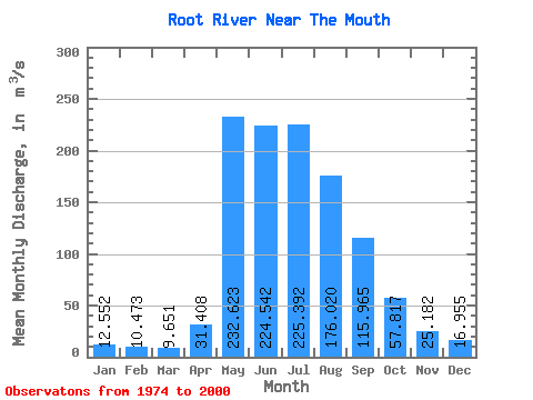
| Statistic | Jan | Feb | Mar | Apr | May | Jun | Jul | Aug | Sep | Oct | Nov | Dec | Annual |
|---|---|---|---|---|---|---|---|---|---|---|---|---|---|
| Mean | 12.55 | 10.47 | 9.65 | 31.41 | 232.62 | 224.54 | 225.39 | 176.02 | 115.97 | 57.82 | 25.18 | 16.95 | 92.35 |
| Standard Deviation | 4.96 | 4.16 | 3.53 | 25.46 | 98.17 | 117.37 | 131.31 | 93.45 | 55.25 | 20.13 | 8.80 | 6.74 | 30.26 |
| Min | 3.31 | 4.45 | 2.51 | 2.60 | 74.70 | 37.00 | 70.30 | 64.70 | 55.70 | 34.20 | 10.60 | 4.10 | 54.75 |
| Max | 22.70 | 20.20 | 18.40 | 86.20 | 451.00 | 556.00 | 658.00 | 401.00 | 286.00 | 109.00 | 50.30 | 29.40 | 159.60 |
| Coefficient of Variation | 0.40 | 0.40 | 0.37 | 0.81 | 0.42 | 0.52 | 0.58 | 0.53 | 0.48 | 0.35 | 0.35 | 0.40 | 0.33 |
 Return to R-Arctic Net Home Page