|
|
|||||||||||||||||
| Point ID: 3616 | Downloads | Plots | Site Data | Code: 10FB006 |
|
|
|||||||||||||||||
| Download | |
|---|---|
| Site Descriptor Information | Site Time Series Data |
| Link to all available data | |
| View: | Time Series | All |
| Units: | mm |
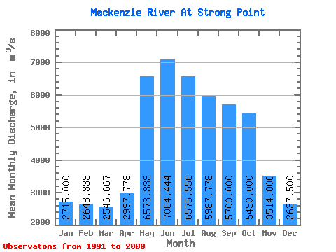
| Statistic | Jan | Feb | Mar | Apr | May | Jun | Jul | Aug | Sep | Oct | Nov | Dec | Annual |
|---|---|---|---|---|---|---|---|---|---|---|---|---|---|
| Mean | 2715.00 | 2648.33 | 2546.67 | 2997.78 | 6573.33 | 7084.44 | 6575.56 | 5987.78 | 5700.00 | 5430.00 | 3514.00 | 2637.50 | 4657.64 |
| Standard Deviation | 743.69 | 751.97 | 686.81 | 668.11 | 1597.28 | 1404.71 | 1267.00 | 1171.79 | 1250.31 | 1189.92 | 1200.33 | 813.54 | 801.13 |
| Min | 1850.00 | 1920.00 | 2030.00 | 2160.00 | 4860.00 | 5240.00 | 4720.00 | 4300.00 | 4030.00 | 3850.00 | 1930.00 | 1910.00 | 3873.33 |
| Max | 3780.00 | 3700.00 | 3650.00 | 4370.00 | 9360.00 | 9350.00 | 8510.00 | 8180.00 | 7740.00 | 7660.00 | 6510.00 | 4090.00 | 5870.83 |
| Coefficient of Variation | 0.27 | 0.28 | 0.27 | 0.22 | 0.24 | 0.20 | 0.19 | 0.20 | 0.22 | 0.22 | 0.34 | 0.31 | 0.17 |
 Return to R-Arctic Net Home Page