|
|
|||||||||||||||||
| Point ID: 36 | Downloads | Plots | Site Data | Code: 05AB018 |
|
|
|||||||||||||||||
| Download | |
|---|---|
| Site Descriptor Information | Site Time Series Data |
| Link to all available data | |
| View: | Time Series | All |
| Units: | mm |
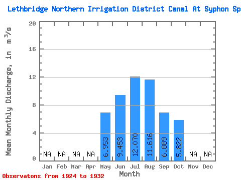
| Statistic | Jan | Feb | Mar | Apr | May | Jun | Jul | Aug | Sep | Oct | Nov | Dec | Annual |
|---|---|---|---|---|---|---|---|---|---|---|---|---|---|
| Mean | 6.95 | 9.45 | 12.07 | 11.62 | 6.89 | 5.82 | |||||||
| Standard Deviation | 3.46 | 6.06 | 6.24 | 5.44 | 2.24 | 2.96 | |||||||
| Min | 2.52 | 2.19 | 1.80 | 4.66 | 4.12 | 2.10 | |||||||
| Max | 12.30 | 16.80 | 20.60 | 20.20 | 9.97 | 8.98 | |||||||
| Coefficient of Variation | 0.50 | 0.64 | 0.52 | 0.47 | 0.33 | 0.51 |
 Return to R-Arctic Net Home Page