|
|
|||||||||||||||||
| Point ID: 3595 | Downloads | Plots | Site Data | Code: 07UC001 |
|
|
|||||||||||||||||
| Download | |
|---|---|
| Site Descriptor Information | Site Time Series Data |
| Link to all available data | |
| View: | Time Series | All |
| Units: | mm |
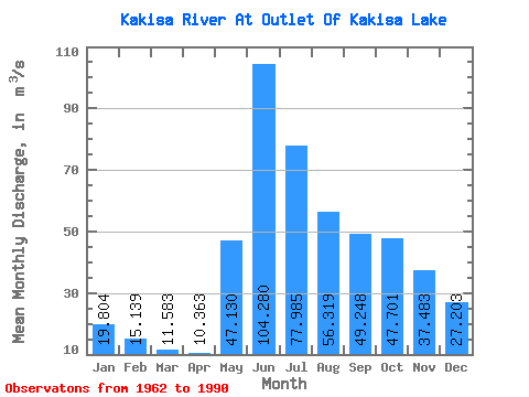
| Statistic | Jan | Feb | Mar | Apr | May | Jun | Jul | Aug | Sep | Oct | Nov | Dec | Annual |
|---|---|---|---|---|---|---|---|---|---|---|---|---|---|
| Mean | 19.80 | 15.14 | 11.58 | 10.36 | 47.13 | 104.28 | 77.98 | 56.32 | 49.25 | 47.70 | 37.48 | 27.20 | 41.04 |
| Standard Deviation | 10.97 | 7.28 | 5.16 | 3.98 | 25.00 | 54.74 | 63.53 | 56.99 | 37.23 | 30.95 | 25.67 | 17.24 | 22.86 |
| Min | 0.89 | 1.82 | 2.48 | 3.45 | 7.11 | 4.36 | 2.28 | 2.73 | 4.14 | 4.44 | 1.92 | 0.55 | 4.38 |
| Max | 39.50 | 27.20 | 20.70 | 19.70 | 128.00 | 214.00 | 333.00 | 326.00 | 205.00 | 124.00 | 86.70 | 60.30 | 123.78 |
| Coefficient of Variation | 0.55 | 0.48 | 0.45 | 0.38 | 0.53 | 0.53 | 0.81 | 1.01 | 0.76 | 0.65 | 0.69 | 0.63 | 0.56 |
 Return to R-Arctic Net Home Page