|
|
|||||||||||||||||
| Point ID: 3578 | Downloads | Plots | Site Data | Other Close Sites | Code: 07SA003 |
|
|
|||||||||||||||||
| Download | |
|---|---|
| Site Descriptor Information | Site Time Series Data |
| Link to all available data | |
| View: | Time Series | All |
| Units: | mm |
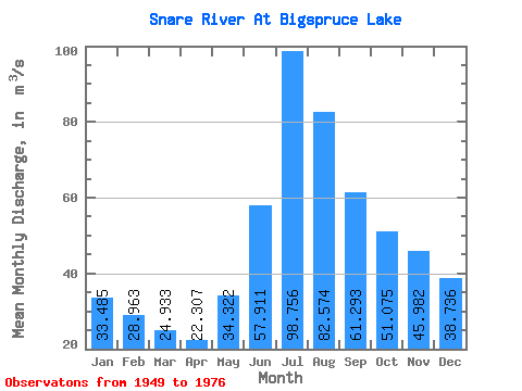
| Statistic | Jan | Feb | Mar | Apr | May | Jun | Jul | Aug | Sep | Oct | Nov | Dec | Annual |
|---|---|---|---|---|---|---|---|---|---|---|---|---|---|
| Mean | 33.48 | 28.96 | 24.93 | 22.31 | 34.32 | 57.91 | 98.76 | 82.57 | 61.29 | 51.08 | 45.98 | 38.74 | 48.53 |
| Standard Deviation | 8.48 | 7.81 | 7.32 | 7.56 | 11.45 | 34.67 | 42.99 | 30.84 | 20.42 | 19.49 | 18.47 | 13.26 | 10.29 |
| Min | 19.70 | 17.30 | 16.10 | 10.70 | 20.20 | 25.30 | 28.10 | 43.80 | 31.70 | 27.80 | 18.40 | 18.40 | 27.17 |
| Max | 49.60 | 57.90 | 54.50 | 53.30 | 63.70 | 147.00 | 200.00 | 161.00 | 127.00 | 110.00 | 87.80 | 66.90 | 65.84 |
| Coefficient of Variation | 0.25 | 0.27 | 0.29 | 0.34 | 0.33 | 0.60 | 0.43 | 0.37 | 0.33 | 0.38 | 0.40 | 0.34 | 0.21 |
| Other Close Sites | ||||||
|---|---|---|---|---|---|---|
| PointID | Latitude | Longitude | Drainage Area | Source | Name | |
| 3576 | "SNARE RIVER BELOW BIGSPRUCE LAKE" | 63.51 | 1279822 | Hydat | ||
 Return to R-Arctic Net Home Page