|
|
|||||||||||||||||
| Point ID: 3575 | Downloads | Plots | Site Data | Code: 07RD001 |
|
|
|||||||||||||||||
| Download | |
|---|---|
| Site Descriptor Information | Site Time Series Data |
| Link to all available data | |
| View: | Time Series | All |
| Units: | mm |
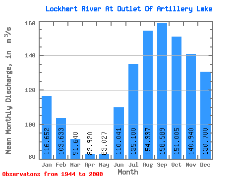
| Statistic | Jan | Feb | Mar | Apr | May | Jun | Jul | Aug | Sep | Oct | Nov | Dec | Annual |
|---|---|---|---|---|---|---|---|---|---|---|---|---|---|
| Mean | 116.65 | 103.63 | 91.64 | 82.92 | 83.03 | 110.04 | 135.10 | 154.34 | 158.59 | 151.00 | 140.94 | 130.70 | 121.88 |
| Standard Deviation | 26.89 | 23.10 | 19.44 | 16.81 | 16.46 | 26.12 | 34.83 | 40.74 | 41.15 | 41.16 | 37.38 | 32.55 | 25.54 |
| Min | 55.30 | 51.20 | 48.10 | 45.00 | 48.20 | 65.30 | 76.10 | 76.10 | 73.10 | 67.40 | 60.70 | 57.00 | 74.11 |
| Max | 184.00 | 157.00 | 134.00 | 120.00 | 117.00 | 208.00 | 256.00 | 275.00 | 266.00 | 241.00 | 227.00 | 210.00 | 184.92 |
| Coefficient of Variation | 0.23 | 0.22 | 0.21 | 0.20 | 0.20 | 0.24 | 0.26 | 0.26 | 0.26 | 0.27 | 0.27 | 0.25 | 0.21 |
 Return to R-Arctic Net Home Page