|
|
|||||||||||||||||
| Point ID: 3571 | Downloads | Plots | Site Data | Code: 07QD004 |
|
|
|||||||||||||||||
| Download | |
|---|---|
| Site Descriptor Information | Site Time Series Data |
| Link to all available data | |
| View: | Time Series | All |
| Units: | mm |
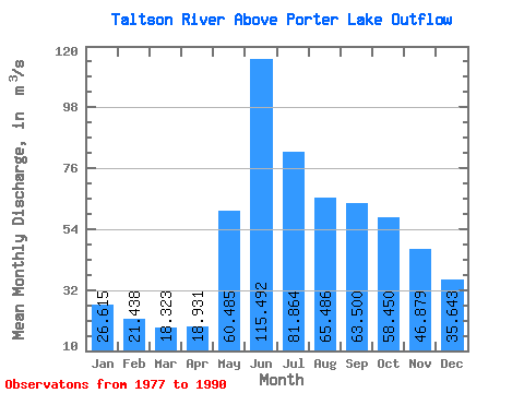
| Statistic | Jan | Feb | Mar | Apr | May | Jun | Jul | Aug | Sep | Oct | Nov | Dec | Annual |
|---|---|---|---|---|---|---|---|---|---|---|---|---|---|
| Mean | 26.61 | 21.44 | 18.32 | 18.93 | 60.48 | 115.49 | 81.86 | 65.49 | 63.50 | 58.45 | 46.88 | 35.64 | 51.70 |
| Standard Deviation | 6.72 | 5.60 | 4.61 | 6.02 | 34.34 | 54.18 | 35.46 | 31.20 | 24.32 | 22.18 | 15.29 | 10.59 | 15.48 |
| Min | 16.60 | 14.20 | 12.30 | 10.50 | 18.30 | 39.20 | 28.00 | 24.60 | 29.70 | 26.10 | 23.00 | 19.70 | 27.93 |
| Max | 39.20 | 29.60 | 24.70 | 31.90 | 129.00 | 231.00 | 179.00 | 154.00 | 111.00 | 98.40 | 72.30 | 53.90 | 85.28 |
| Coefficient of Variation | 0.25 | 0.26 | 0.25 | 0.32 | 0.57 | 0.47 | 0.43 | 0.48 | 0.38 | 0.38 | 0.33 | 0.30 | 0.30 |
 Return to R-Arctic Net Home Page