|
|
|||||||||||||||||
| Point ID: 357 | Downloads | Plots | Site Data | Code: 05BN019 |
|
|
|||||||||||||||||
| Download | |
|---|---|
| Site Descriptor Information | Site Time Series Data |
| Link to all available data | |
| View: | Time Series | All |
| Units: | mm |
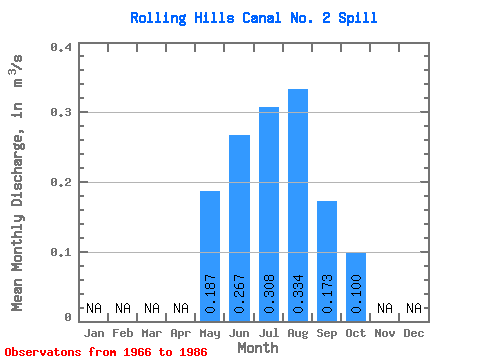
| Statistic | Jan | Feb | Mar | Apr | May | Jun | Jul | Aug | Sep | Oct | Nov | Dec | Annual |
|---|---|---|---|---|---|---|---|---|---|---|---|---|---|
| Mean | 0.19 | 0.27 | 0.31 | 0.33 | 0.17 | 0.10 | |||||||
| Standard Deviation | 0.10 | 0.10 | 0.12 | 0.13 | 0.12 | 0.08 | |||||||
| Min | 0.02 | 0.02 | 0.07 | 0.19 | 0.00 | 0.00 | |||||||
| Max | 0.47 | 0.41 | 0.54 | 0.61 | 0.42 | 0.32 | |||||||
| Coefficient of Variation | 0.52 | 0.38 | 0.39 | 0.40 | 0.67 | 0.80 |
 Return to R-Arctic Net Home Page