|
|
|||||||||||||||||
| Point ID: 3534 | Downloads | Plots | Site Data | Code: 06LC001 |
|
|
|||||||||||||||||
| Download | |
|---|---|
| Site Descriptor Information | Site Time Series Data |
| Link to all available data | |
| View: | Time Series | All |
| Units: | mm |
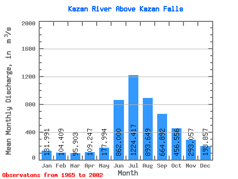
| Statistic | Jan | Feb | Mar | Apr | May | Jun | Jul | Aug | Sep | Oct | Nov | Dec | Annual |
|---|---|---|---|---|---|---|---|---|---|---|---|---|---|
| Mean | 131.99 | 104.41 | 95.90 | 109.25 | 177.99 | 862.00 | 1224.42 | 893.65 | 664.89 | 456.56 | 293.06 | 193.86 | 437.98 |
| Standard Deviation | 50.14 | 40.62 | 39.52 | 43.95 | 80.48 | 270.49 | 340.34 | 209.52 | 137.63 | 105.48 | 74.97 | 64.32 | 59.40 |
| Min | 30.50 | 29.00 | 27.20 | 42.80 | 46.30 | 451.00 | 567.00 | 445.00 | 488.00 | 261.00 | 109.00 | 34.50 | 322.11 |
| Max | 223.00 | 185.00 | 186.00 | 218.00 | 393.00 | 1730.00 | 1950.00 | 1320.00 | 1000.00 | 721.00 | 484.00 | 366.00 | 532.42 |
| Coefficient of Variation | 0.38 | 0.39 | 0.41 | 0.40 | 0.45 | 0.31 | 0.28 | 0.23 | 0.21 | 0.23 | 0.26 | 0.33 | 0.14 |
 Return to R-Arctic Net Home Page