|
|
|||||||||||||||||
| Point ID: 3532 | Downloads | Plots | Site Data | Other Close Sites | Code: 06KC003 |
|
|
|||||||||||||||||
| Download | |
|---|---|
| Site Descriptor Information | Site Time Series Data |
| Link to all available data | |
| View: | Time Series | All |
| Units: | mm |
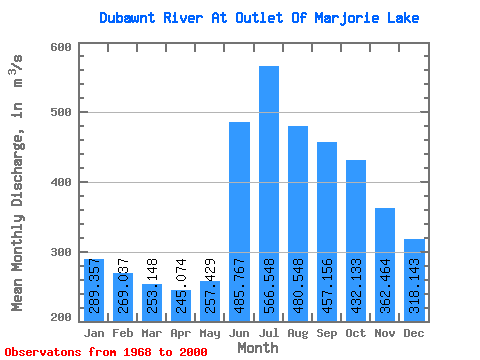
| Statistic | Jan | Feb | Mar | Apr | May | Jun | Jul | Aug | Sep | Oct | Nov | Dec | Annual |
|---|---|---|---|---|---|---|---|---|---|---|---|---|---|
| Mean | 289.36 | 269.04 | 253.15 | 245.07 | 257.43 | 485.77 | 566.55 | 480.55 | 457.16 | 432.13 | 362.46 | 318.14 | 366.10 |
| Standard Deviation | 77.57 | 74.11 | 68.05 | 59.66 | 53.81 | 118.57 | 122.55 | 103.38 | 90.58 | 93.28 | 87.66 | 82.06 | 66.70 |
| Min | 157.00 | 146.00 | 142.00 | 150.00 | 156.00 | 264.00 | 354.00 | 299.00 | 307.00 | 247.00 | 190.00 | 174.00 | 248.83 |
| Max | 435.00 | 422.00 | 410.00 | 394.00 | 380.00 | 840.00 | 791.00 | 651.00 | 653.00 | 629.00 | 584.00 | 498.00 | 494.42 |
| Coefficient of Variation | 0.27 | 0.28 | 0.27 | 0.24 | 0.21 | 0.24 | 0.22 | 0.21 | 0.20 | 0.22 | 0.24 | 0.26 | 0.18 |
| Other Close Sites | ||||||
|---|---|---|---|---|---|---|
| PointID | Latitude | Longitude | Drainage Area | Source | Name | |
| 3531 | "DUBAWNT RIVER BELOW MARJORIE LAKE" | 64.34 | 480648 | Hydat | ||
 Return to R-Arctic Net Home Page