|
|
|||||||||||||||||
| Point ID: 352 | Downloads | Plots | Site Data | Code: 05BN013 |
|
|
|||||||||||||||||
| Download | |
|---|---|
| Site Descriptor Information | Site Time Series Data |
| Link to all available data | |
| View: | Time Series | All |
| Units: | mm |
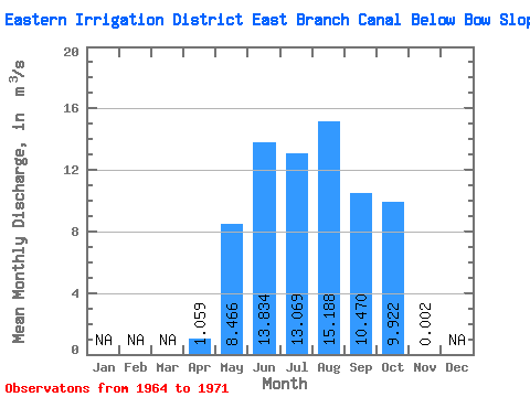
| Statistic | Jan | Feb | Mar | Apr | May | Jun | Jul | Aug | Sep | Oct | Nov | Dec | Annual |
|---|---|---|---|---|---|---|---|---|---|---|---|---|---|
| Mean | 1.06 | 8.47 | 13.83 | 13.07 | 15.19 | 10.47 | 9.92 | 0.00 | |||||
| Standard Deviation | 0.69 | 4.08 | 3.72 | 4.68 | 3.61 | 6.11 | 3.99 | ||||||
| Min | 0.57 | 1.31 | 7.47 | 5.91 | 10.30 | 2.42 | 6.46 | 0.00 | |||||
| Max | 1.55 | 14.00 | 18.40 | 18.60 | 20.60 | 19.70 | 17.80 | 0.00 | |||||
| Coefficient of Variation | 0.66 | 0.48 | 0.27 | 0.36 | 0.24 | 0.58 | 0.40 |
 Return to R-Arctic Net Home Page