|
|
|||||||||||||||||
| Point ID: 350 | Downloads | Plots | Site Data | Code: 05BN011 |
|
|
|||||||||||||||||
| Download | |
|---|---|
| Site Descriptor Information | Site Time Series Data |
| Link to all available data | |
| View: | Time Series | All |
| Units: | mm |
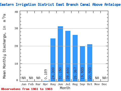
| Statistic | Jan | Feb | Mar | Apr | May | Jun | Jul | Aug | Sep | Oct | Nov | Dec | Annual |
|---|---|---|---|---|---|---|---|---|---|---|---|---|---|
| Mean | 0.19 | 24.30 | 31.15 | 28.60 | 26.37 | 19.93 | 20.93 | ||||||
| Standard Deviation | 2.12 | 1.20 | 5.58 | 8.84 | 7.22 | 5.50 | |||||||
| Min | 0.19 | 22.80 | 30.30 | 22.20 | 16.20 | 12.40 | 15.90 | ||||||
| Max | 0.19 | 25.80 | 32.00 | 32.40 | 32.20 | 26.80 | 26.80 | ||||||
| Coefficient of Variation | 0.09 | 0.04 | 0.20 | 0.34 | 0.36 | 0.26 |
 Return to R-Arctic Net Home Page