|
|
|||||||||||||||||
| Point ID: 349 | Downloads | Plots | Site Data | Code: 05BN010 |
|
|
|||||||||||||||||
| Download | |
|---|---|
| Site Descriptor Information | Site Time Series Data |
| Link to all available data | |
| View: | Time Series | All |
| Units: | mm |
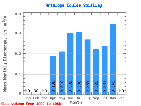
| Statistic | Jan | Feb | Mar | Apr | May | Jun | Jul | Aug | Sep | Oct | Nov | Dec | Annual |
|---|---|---|---|---|---|---|---|---|---|---|---|---|---|
| Mean | 0.19 | 0.21 | 0.30 | 0.31 | 0.27 | 0.22 | 0.24 | 0.34 | |||||
| Standard Deviation | 0.15 | 0.23 | 0.24 | 0.23 | 0.26 | 0.42 | 0.48 | ||||||
| Min | 0.19 | 0.01 | 0.02 | 0.01 | 0.05 | 0.00 | 0.01 | 0.00 | |||||
| Max | 0.19 | 0.63 | 1.21 | 0.92 | 1.03 | 1.17 | 2.06 | 0.69 | |||||
| Coefficient of Variation | 0.71 | 0.75 | 0.78 | 0.85 | 1.18 | 1.78 | 1.41 |
 Return to R-Arctic Net Home Page